


Patagonia: Part 2
- Erin
- Mar 17, 2019
- 14 min read


After a relaxing and productive few days in Chile Chico, it was time to cross the border again and begin the section of the trip that both Brian and I were somewhat dreading. We had read ride reports and heard from countless other travelers that this particular section of Ruta 40 contained some of the worst wind and road conditions. We had talked to numerous other riders who knew someone that had been blown off of their bike or fallen and broken a bone on this treacherous stretch of road. But alas, it was the only option to get south to where we wanted to go, so off we went.
A big part of our planning for this section was trying to time it well with the weather. Brian and I downloaded at least four different wind/weather applications on our phones in an attempt to find the perfect weather window. After some deliberation, we decided to only ride 70 kilometers across the border the next day to a small town called Perito Moreno to set us up better for the following two days. Knowing that the wind is always worse in the afternoon (and confirming this with our wind apps which said the gusts would be up to 45 mph by 11 am the following day) we thought it would be a good idea to get a super early start the next day - and I mean early! When our alarm clocks went off at 3:10 am, we momentarily questioned our decision, but seeing as the forecast hadn't changed, we suited up and hit the road in the dark. The cold air was biting as we rode off with every layer of clothing we could fit under our riding gear. All was going well for the first few hours. We rode slow to be safe, dodging potholes and the occasional rabbit that darted in front of us. After a little over three hours, the sun began to rise and we arrived at a super small town (two streets by two streets) called Bajo Caracoles. This little town is notorious for gas shortages that can leave people stranded for days, so we came prepared with plenty of extra fuel. We still stopped in the town, however, with the hopes of sneaking inside someplace to warm up our now freezing fingers and toes.


Unfortunately but not surprisingly, no place was open at 7:00 am, so we hopped on our bikes and continued into the teeth-chattering cold. About 15 kilometers away from the town, it began to snow. Yes, that's right...snow!
Our forecasts had failed us in this department as the temperature was supposed to be 45 degrees Fahrenheit at this time. We attempted to ride on, but the conditions were miserable. My fingers and toes, which had been feeling like pins and needles for the last hour despite our heated grips, were now completely numb. With visibility getting worse, and knowing we still had 200+ kilometers to go, we decided to turn around and head back to Bajo Caracoles in hopes of finding a warm place to wait out the snow.
Luckily, the only hotel in town was now open and they had a small convenience store with a coffee machine and a few tables and chairs.
*The ending of this video is proof that Brian and I have spent way too much time together these last 6 months.
The snow continued to fall for the next two and a half hours while we sat in the shop, struggling to keep our eyes open from our self-inflicted sleep deprivation. Our early departure wasn't all in vain, however, as we met a few other riders who had also stopped in the shop to escape the cold and we exchanged route advice and stories. Finally, the snow subsided and the sun came out. We rode another 120 kilometers before stopping at a restaurant & hotel in the middle of nowhere that had been recommended to us by some riders we met in the shop. A couple of hot chocolates and 30 minutes by the wood-fire stove gave us enough energy for the final push to Gobernador Gregores, a small mining town that provided a good stopping point on our way to El Chaltén. Upon arriving in the town, we went out for a quick dinner and then fell fast asleep in our warm bed.

Not wanting to make the same mistake the following day, we awoke at a more reasonable hour and were on the road by 8:00 am. The previous day's route was challenging due to wind and weather, but this day's route was adding a new challenge: 75 kilometers of notoriously horrible corrugated gravel road. We were insanely lucky with the weather as our forecast held true and we had barely any wind and no rain. I can only imagine how awful this road would have been if we had not been so lucky. The entire 75 kilometers consisted of constantly shifting tire tracks surrounded by thick gravel creating a "choose your own adventure" game as the once good track could suddenly turn into thick gravel and require a crossing over of even thicker gravel. A big gust of wind would have easily set us off course, but we both made it through without dropping our bikes.


With a celebratory fist in the air, the worst was behind us and we set off down the pavement!

Before long, we could spot the famous Fitz Roy Range and the rest of the towering Andes peaks that surround El Chaltén.


El Chaltén is a small tourist town in Los Glaciares National Park that would be our jumping off point for some trekking over the next week. After riding all over town in an attempt to find affordable lodging (which we learned doesn't really exist), Brian was able to negotiate down the price for a room at a hotel not too far from the center. We spent the evening relaxing and discussing plans for the upcoming days.
We had read online and heard from another traveler that the Huemul Circuit is not to be missed. In fact, it is listed as one of the top five treks in the world (albeit on one of those arbitrary online ranking lists). It involves four days of self-guided trekking on sometimes unmarked paths with all of your own food and gear, including a harness and rope to propel yourself across two rivers - and the best part - all camping and park entrance is free! Needless to say, we were very interested. We walked to the ranger's station the next morning to watch the mandatory safety video and gather more information. We then went into town to rent our harnesses and trekking poles and gather food provisions.
Huemul Circuit Day 1 - 16 kilometers (10 miles)
We were able to leave the bikes at the hotel, so the next morning we walked to the trail head with just our backpacks and trekking poles. The start of the trek (like most treks in El Chaltén) was a short walk outside of town, giving us excellent views of the famous Fitz Roy peaks on our way.


The first day involved traversing through green meadows with wild cattle, climbing up into a wooded forest with caterpillars covering the ground and dropping from the trees, and crossing streams down into a valley along the Tunel river until we arrived at the Laguna Toro campsite. We had great weather the entire day other than a 10 minute sprinkle of rain and arrived at the campsite with just enough energy to set up our tent, cook dinner, and go to bed. We were able to sleep in a "bird nest" of tree branches created by previous trekkers for a little extra wind protection.


Huemul Circuit Day 2 - 17 kilometers (10.6 miles)
The following morning, we awoke at sunrise to eat breakfast, take down our tent, and hit the trail. Unlike the first day, which had a pretty discernible trail, this day's route required some navigation with our phones and stone cairns. Luckily, we had downloaded the route on maps.me because there were many sections that were far from obvious. At one point early in the day, we found ourselves rock climbing up a 20+ ft wall.

Fortunately, there was a stone cairn at the top which confirmed we had not just scaled the giant wall for nothing. Before long, we arrived at our first pulley crossing over a raging river 30 ft below. Brian went first, landing on the precariously steep rock ledge on the other side.
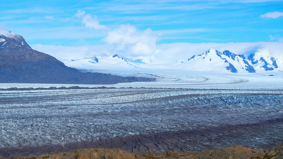
I recovered the pulley with a rope and then it was my turn. Brian had made it look easy, but I struggled a bit on the last third of the line which had a slight incline (my 35+ lb backpack did not help in making things any easier). Once on the other side, we continued ascending up the mountainside. After a few kilometers of loose scree, we arrived at the Viedma Glacier. At this point, we had conflicting information on our downloaded maps, so we forged our own path down toward the ice, loosely referencing one of them. It was a steep decline with lots of loose scree, but eventually we made it down. Many sections of the glacier close to the mountainside had enough dirt and rocks on it that crampons were not necessary. Brian and I, however, followed a GPS track that ventured a little further out onto the ice for some epic views down into the various crevasses.


After 45 minutes on the ice, we began the super steep ascent off of the glacier and up to the Paso del Viento (Wind Pass). Ironically, once we got to the top, there was very little wind. After catching our breath, we looked back on the massive glacier we had just traversed and then took in our first views of the Southern Patagonian Ice Field on the other side. This ice field is the 3rd largest ice mass and 3rd largest reserve of fresh water in the world after Antarctica and Greenland, and the Huemul Circuit is one of the few ways to get a 180 degree panoramic view of it.


Many pictures and a snack break later, we began making our way down the other side of the pass. After walking along the ice field for a while, we descended all the way down into a valley which eventually led us to our campsite for the night. Absolutely exhausted, we set up our tent and struggled to find enough energy to make dinner. Realizing we had over-packed on food, we made some friends with our Belgian neighbors who had mentioned they did not pack enough and gave them some of our surplus food. It was a win-win for everyone as our backs would thank us for the decrease in weight over the next two days.


Huemul Circuit Day 3 - 16 kilometers (10 miles)
Day three began with a beautiful sunrise and only a few clouds in the sky. Although we had been extremely lucky with the weather thus far as there was little wind, little rain, and warmer temperatures than expected, this was the first day of actual sunshine. The first two thirds of the day gave us more epic views of the Southern Patagonian Ice Field as we made our way toward the Huemul Mountain pass.


Eventually, it was time to begin the steep ascent up the Huemul Mountain. Once we got to the top we encountered some strong winds, but were rewarded with the most stunning view of the ice field yet.


After taking in the scenery from the top, we made our way to the hardest part of the trek: an INSANELY steep descent from 900 m to 300 m (a drop of about 2,000 ft) in the course of about 1 km (0.6 miles). At some points, the path was near vertical and this is no exaggeration. We had to grab onto the surrounding bushes (when available) to avoid somersaulting down the mountainside. It took us over three hours to complete this part due to its difficulty (read: my struggle to stay upright while Brian made it look easy). Of course, pictures do not do it any justice, and we didn't take any after the first 50 m in order to concentrate. The only consolation for the utter misery was the view of the icebergs in the bay down below.


Many expletives, near-falls, and actual falls later, we had finally arrived at the bottom! We walked with achy knees the remaining distance to our campsite right on the water with a view of the ice bergs and the edge of the Southern Ice Field from which they came.


We set up camp, ate dinner, and then began to drift to sleep. About 10 minutes after lying down, however, our plans for sleep were suddenly halted. Throughout the early evening we had become accustomed to the sound of an occasional ice piece calving from the ice field in the distance. Typically, it lasted 3-5 seconds and then the sound dissipated. Hence, when we heard this familiar sound for one going on two minutes straight, Brian and I both shot up in our sleeping bags and walked out into the cold night air. With the rumbling sound still going, a few others began to stir from their tents. Since it was pitch black, it was impossible to see what was happening in the distance. One guy decided to take his headlamp and walk down the rocky beach to investigate. All of a sudden, a large wave charged at him and he quickly turned around, rock hopping as fast as he could back to the campsite. The wave had made it halfway up the once calm beach toward where our tents were situated. It was at this moment that Brian began shouting for everyone to wake up. As people emerged sleepy-eyed from their tents, we all quickly put on our shoes and bolted up the hill behind the campsite. The calving sound had lasted for almost FIVE straight minutes, and as we stood up on the hill, the sound of the waves intensified. We half worriedly, half jokingly talked about how we might not have a campsite when we returned. After about 10 anxious minutes, the waves began to subside. We waited an additional 10 minutes to be safe before making our way back down to determine if we still had tents or if our campsite had been washed away. Luckily, when we arrived at the bottom everything was in its place with no signs of flooding. We are still unsure how high the water had eventually come, but at least we know it never reached our tents. Even still, try falling back asleep after that! Since the following day was my birthday, I can definitely say 28 ended with a bang!
Humeul Circuit Day 4 - 15 kilometers (9.3 miles)
Despite our adrenaline, we did eventually fall back asleep. We awoke the following morning to a gorgeous sunset over the bay. Our Belgian friends sang me happy birthday and I sipped on my coffee, feeling true appreciation for where I was starting out my 29th year.


The final day of the trek had the least elevation gain/loss, and we found ourselves walking around a large lagoon, up and down rolling hills overlooking the iceberg-filled bay, and through flat grasslands until we reached our second pulley crossing. This time, with the help of another couple, we decided to send our bags over separately to make the longer crossing a little easier. To our surprise, however, this crossing was unlike the last. It took very little effort and was more like a zip-line.


Once on the other side, we walked the remaining few kilometers to the technical end of the trek at the Bahia Tunel ferry dock. We had read online and confirmed with the park rangers that we should be able to hitchhike the seven kilometers back to town if we waited for a ferry to arrive. To our unfortunate surprise, however, the ferry was not operating that day. In the distance we saw two familiar faces waving us over. It was two of our Belgian friends! They notified us that their significant others were jogging back to town to grab their car and then come pick them up. They offered to give us a ride if we wanted to wait with them. I could not have asked for a better birthday present!
Unbeknownst to us, the town was preparing for a festival that weekend and there was now a police checkpoint at the entrance. When we rolled up with our overloaded car without any passports (we had to leave our passports at the gear rental shops), it took a little explaining before the confused officers let us into town. Laughing at the situation, we finally arrived back at our hotel and collapsed on the bed. After 4 days of not showering, we took our longest showers of the trip before forcing ourselves back outside to get dinner. We then met up with our Belgian friends for a fun night of chatting over drinks, complete with a birthday serenade from a traveling band.
I could not have asked for a better birthday or better trek (insane downhill section aside). The thing that makes this trek so special is that although it has become more popular over the last couple of years, it is still a much less trodden trail than most in Patagonia. Even with the 15 or so other groups, we rarely saw anyone else on the route most days due to slightly different departure times. Also, because the middle two days of this trek are not accessible to day hikers, we were able to experience the surrounding sounds, smells, and raw beauty without any interruptions from other noisy tourists, which is a luxury that we did not find anywhere else during our time in Patagonia.
We spent the next two days sleeping in, relaxing, and attending the free National Trekking Festival concert. This annual festival commemorates the first Argentine attempt to summit Mount Fitz Roy in March 1948.
Finally feeling recovered from our trek, it was time to explore one of the more popular trails near El Chaltén. We decided to do one called Monte Fitz Roy/Tres Lagos, which would take us as close as you can get to the famous Fitz Roy peaks. Unfortunately, the clouds from the rainy weather the previous day had decided to stick around, and it was very overcast. We made it all the way to the base of the final and steepest kilometer, but we were still unable to see even the slightest glimpse of the peaks. We heard from other hikers coming down that the visibility and wind were almost unbearable at the top so we decided to try and wait out the rain and clouds. We ate lunch and sat for over an hour with no change in visibility. After hearing yet another account of the horrible conditions at the top from someone who had just descended, we opted to turn around and make our way back into town. Even without the quintessential view, we enjoyed the hike. Perhaps if we are ever in Patagonia again, we will return to conquer this trail.


Feeling content with our time in El Chaltén, we packed up our bikes the following morning and headed toward El Calafate, a town situated near the famous Perito Moreno Glacier. It was a cold and windy ride, but we arrived in town without issue. Since we had been unable to do the Exploradores Glacier trek near Puerto Rio Tranquilo (see last post), we were excited to do some trekking on the Perito Moreno Glacier. The Perito Moreno Glacier is unique in that it is one of the few glaciers in the world that is in balance - not retreating/shrinking. It both grows and ruptures two meters (almost seven feet) per day. The glacier boasts an impressive height of 74 meters (240 feet) above the surface of Lago Argentino and also reaches a total depth of 170 meters (558 feet) below the water’s surface. On any given day, you can hear and see massive pieces of ice calving off of the glacier's edge. It sounds like rumbling thunder and is an impressive sight to see. Brian and I booked a glacier trek for two days from our arrival date when the weather was predicted to be best. We spent the following days relaxing, blogging, and performing our own oil changes on the bikes. We also officially posted the bikes for sale. *tear*
On the day of our trek, we rode the 80 kilometers to the glacier park entrance. We spent the morning on the catwalks overlooking the sun-covered glacier, listening to the sounds of the ice calving and taking in the awe-inspiring view.


Before we knew it, it was time to ride to the nearby port to catch our ferry over to the glacier for our trek. After learning about the glacier from our guide, we donned our crampons and took to the ice. We spent the next hour and a half exploring the various crevasses and seracs on the edge of this massive structure. The tour ended with a glass of whiskey poured over some fresh glacial ice.


We decided we still had not gotten enough of this natural wonder, so after our tour we headed back to the catwalks to catch the sunset. The setting sun cast gorgeous shadows over the glacier's surface, making for an even more magical view.


Feeling pretty happy about life, we rode back to town, stopping to take in some final views of the beautiful sunset.


The next day would be spent planning for the culmination of our time in Patagonia: Torres del Paine National Park!
Cheers,
Erin and Brian


Comments